
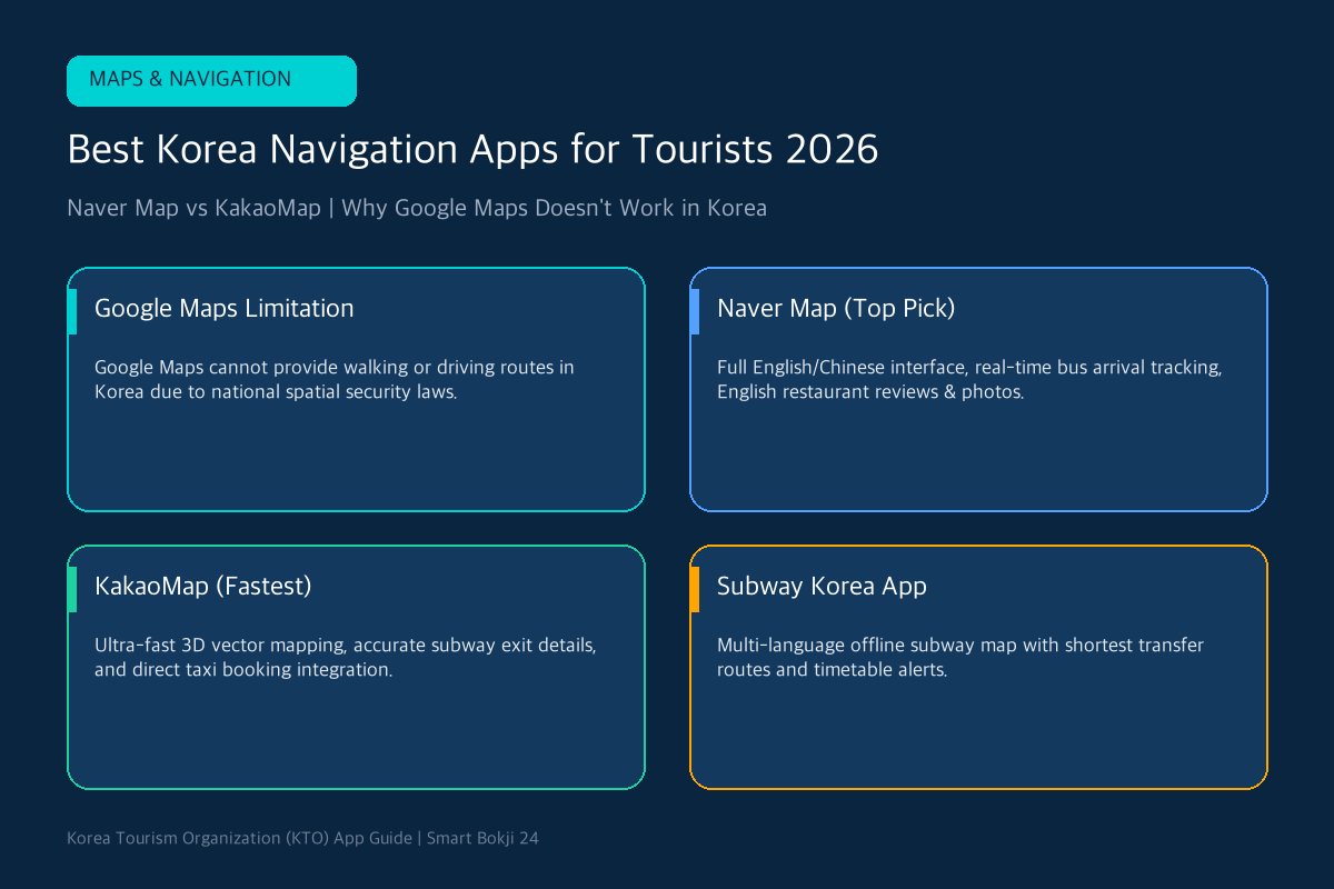
Welcome to the complete guide on the best Korea navigation apps for tourists in 2026! One of the biggest surprises for international travelers arriving in South Korea is discovering that Google Maps cannot provide walking or driving directions. Due to South Korean national spatial data security regulations, foreign tech companies cannot export high-precision military-grade map data onto overseas cloud servers.
To explore Seoul, Busan, and Jeju without getting lost, downloading the best Korea navigation apps for tourists—specifically Naver Map and KakaoMap—is essential. In this guide, we break down why local Korean map apps dominate, compare English language features, and show you step-by-step how to navigate public transit, subways, and walking routes like a local.
While Google Maps can show static business pins, it fails completely for turn-by-turn pedestrian and vehicle navigation in South Korea:
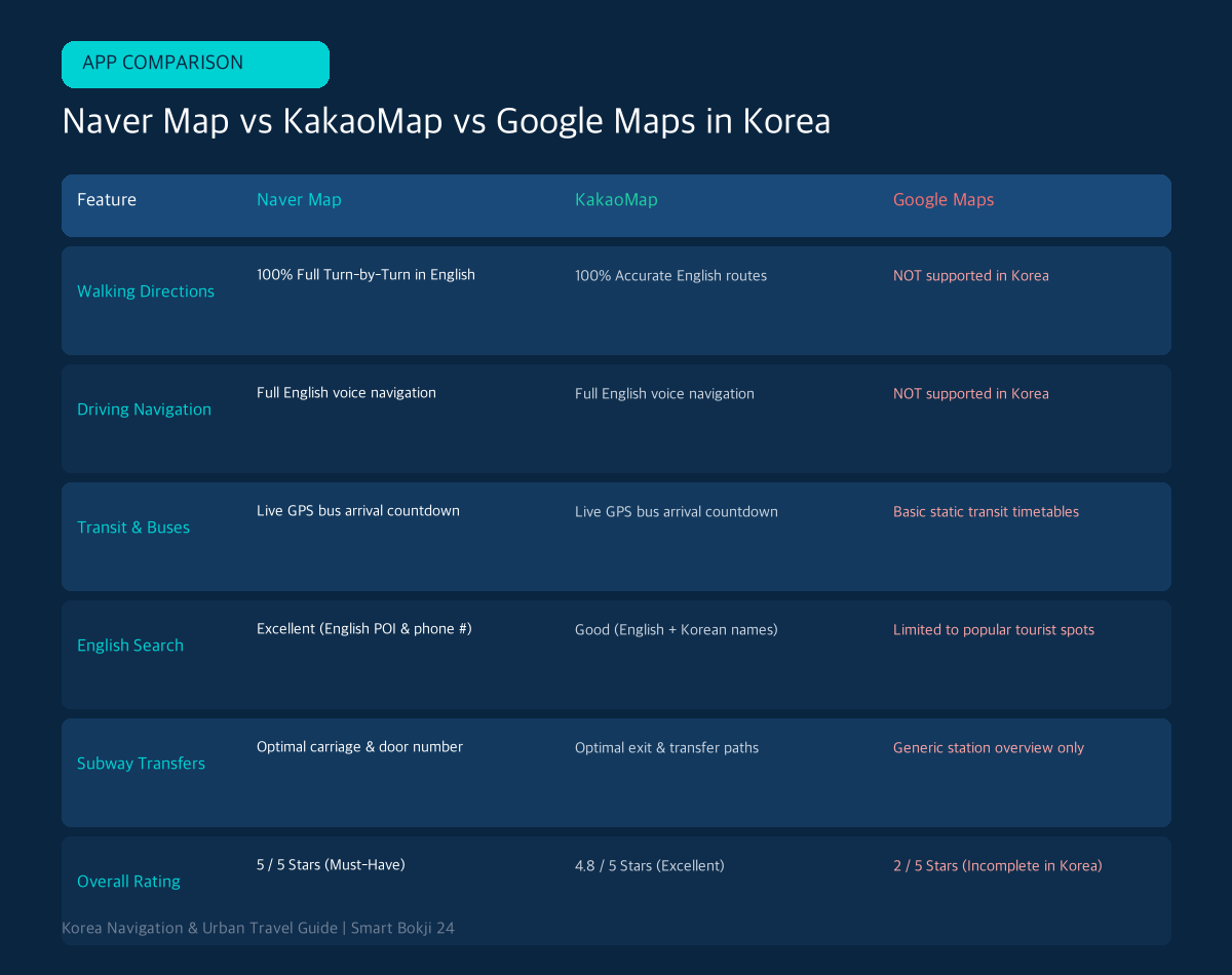
- 100% Full English & Chinese Interface: Every street name, subway exit, and bus stop is clearly translated.
- Live GPS Bus Tracking: Shows real-time bus countdowns and exact congestion levels (empty, seats available, standing only).
- Phone Number Search: Simply paste any Korean restaurant or cafe phone number (e.g., 02-123-4567) into the search bar to locate it instantly!
- Official Source: Korea Tourism Organization (VisitKorea).
- Official Source: Seoul Metropolitan Government.
2. Key Features of KakaoMap & Subway Korea
- KakaoMap (카카오맵): Features ultra-smooth 3D vector graphics, accurate indoor floor plans for massive shopping malls (COEX, The Hyundai Seoul), and direct integration with Kakao T for taxi hailing.
- Subway Korea (지하철): The top standalone offline subway map app. Provides the fastest transfer carriage numbers, door exit tips, and live train timetable countdowns across Seoul, Busan, Daegu, Daejeon, and Gwangju.
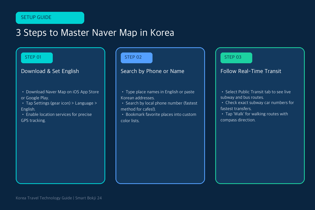
- Step 1: Download & Switch Language: Install Naver Map from the iOS App Store or Google Play. Tap the three-line menu icon > Settings (gear icon) > Language > select English.
- Step 2: Search Destinations: Type place names in English (e.g., Gyeongbokgung Palace or Myeongdong Night Market). If searching small cafes or street restaurants, copy the Korean address from Instagram or paste the local phone number directly into the search bar.
- Step 3: Choose Public Transit or Walk: Tap Public Transit to see color-coded subway and bus routes with departure countdowns. Tap Walk for precise pedestrian turn-by-turn navigation with compass orientation.
4. Frequently Asked Questions (FAQ)
Q1: Can I use Naver Map offline without internet data?
Live route calculations and bus countdowns require mobile data. However, you can cache city map regions and bookmark favorite locations while on hotel Wi-Fi.
Q2: Does Apple Maps work in South Korea?
Apple Maps works better than Google Maps for basic driving directions, but Naver Map remains significantly more accurate for public transit and walking paths.
🔗 Recommended Travel Tech & Transit Guides
- 10 must-have apps for travelers: Read our Top 10 Must-Have Apps for Traveling in Korea 2026.
- Unlimited transit pass: Check the Korea Climate Card vs T-Money Transit Guide.
- Official Source: Korea Tourism Organization (VisitKorea).
- Official Source: Seoul Metropolitan Government.
Why the apps may show different routes
Naver Map and KakaoMap can rank transfers, walking routes, and bus arrivals differently. Compare the station exit number and the Korean destination name, not just the estimated minutes. In dense neighborhoods, the correct exit can save more time than choosing the nominally fastest subway route.
Save the Korean address and a screenshot of the final walking section. Pin your hotel before leaving it and check the last train or bus separately for late-night trips. GPS may drift inside stations and underground shopping areas, so follow platform numbers and street-level landmarks. Never rely on a single live route when catching a timed airport or intercity connection.